
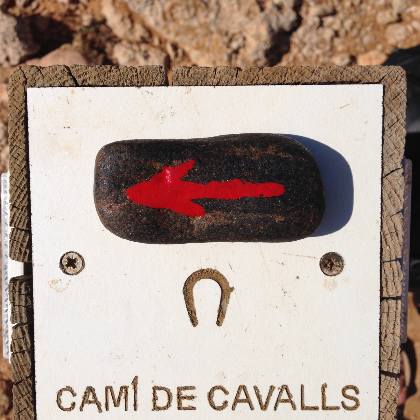
Before starting something new it is a good idea to at least summarize the old thing. A strange little project, mainly published on instagram, has been going on since 2014, with a sliding beginning, but a very clear ending. See here. The first image was posted 22 July 2015 on Menorca (see the image above). It was the first image I ever posted on instagram, a picture of the stone against ultramarin blue paint on a wall on Menorca. The last image was taken on the beach in Jandia on Fuerteventura on the last day of the year 2017, deliberately as an ending of the project.

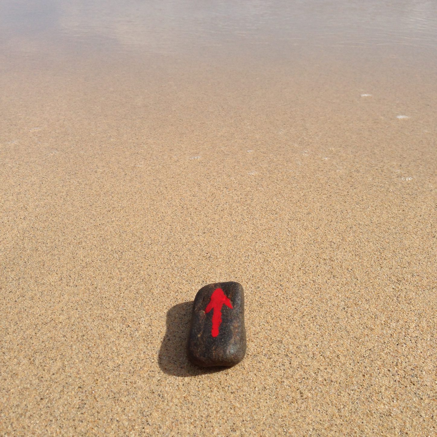
Actually the first time the small stone with the red arrow shows up on this blog or is mentioned anywhere, is in a post from Oulanka Nature Park on 14 September 2014. There I write about “some experiments with a small pebble I picked on Harakka Island earlier and painted a red arrow on, somewhat reminiscent of the double happiness sign I painted on a roof tile in Farrera in 1999, which resulted in the video work Double Happiness in Water (2001). This pebble with the arrow I placed in the corner of the image, pointing towards something worth focusing on.” (see the blog post here) And as it happens the arrow is pointing at water in that image.

The point of the project on instagram was to use the arrow to point at water in various forms, to highlight our dependence on water and the importance of water for life on the planet, as well as the various forms that water can take, its many transformations and uses. And to experiment with social media as a platform for a project, of course. Many of the images in the beginning contain drinking water, while most of the later images are beautiful landscapes with water in the background. My idea was to use instagram for a specific project, not for images in general, as most people do, but every now and then I added also images without the arrow. Before writing these notes I went through them and deleted all the others, to make the documentation ”clean”, thus the arrow images posted on instagram are now 210. What to do with the rest of the images – there are of course a lot more of them than the ones posted on instagram, and many variations of those ones, too – is another problem. The main reason for making these notes is to close the project in some manner, in order to begin a new one, which I describe briefly here.
Category Archives: Uncategorized

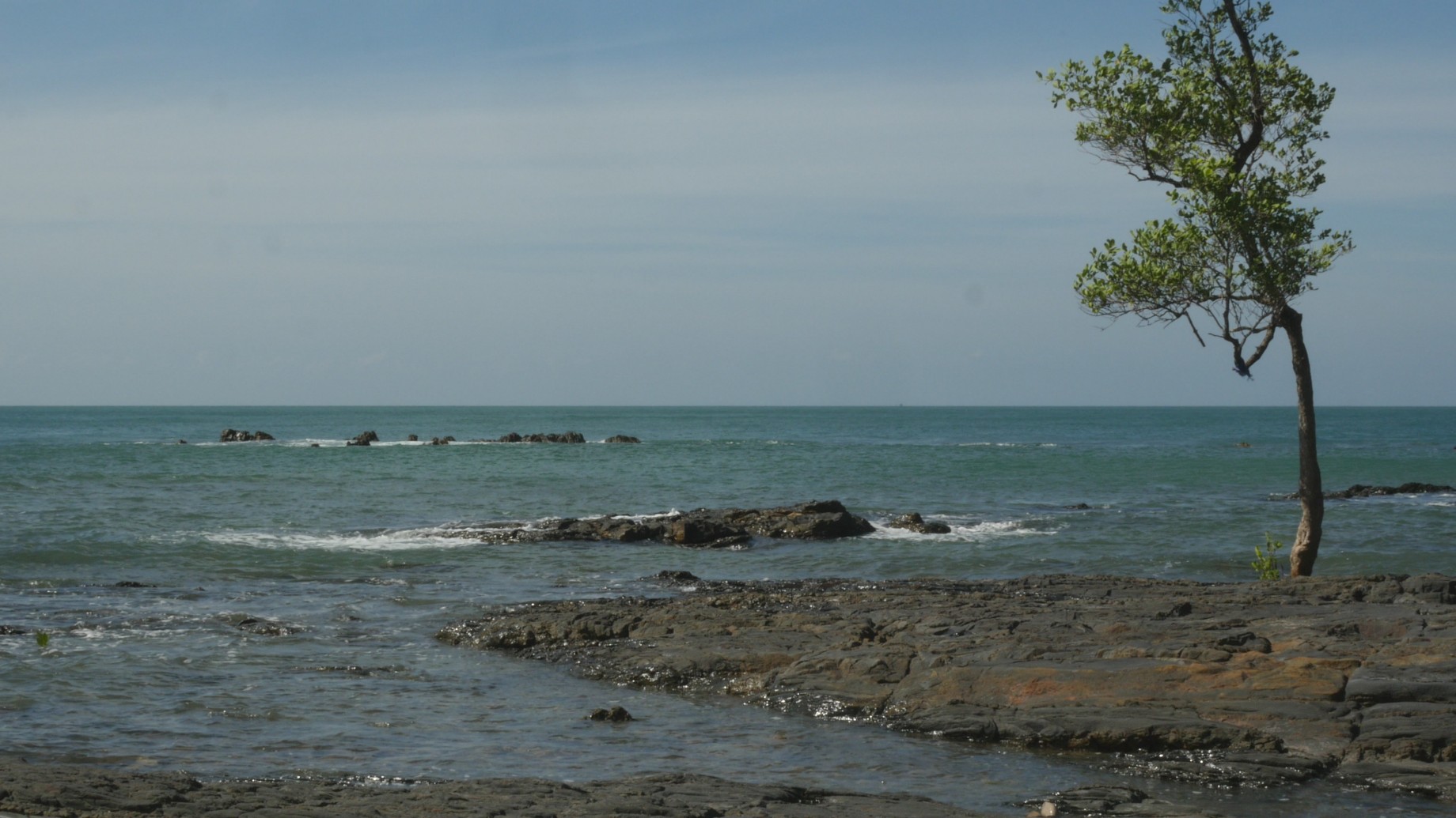
The Tide at Kan Tiang Beach
Arriving at Kan Tiang Beach in the peaceful southern part of Koh Lanta felt like a relief, partly because it was nice to be in a small tourist village instead of the hustle and bustle of Christmas in a tourist town like Ao Nang, partly because the feeling of being in the countryside was inspiring. Looking at the tide coming in and going out on the rocky beach yesterday made me decide that I would want to record the tide somehow. And today my travelling companion wanted to go to a small rocky cove nearby, because that would be a good place for snorkeling. The morning was windy and I had no desire trying to do some snorkeling in rough sea – I have bad experiences of that before – but the idea of a small rocky cove sounded ideal for recording the tide, so I was happy to follow on the entangled path through the jungle. It was not far, but we lost the path and had to press ourselves through some heavy bushes, uh, and I was afraid I would never find my way out from there again. The cove was pretty and secluded, though. And I soon discovered the path from the beach, so I was not afraid of staying there on my own. It was only a few hours before high tide, and a small tree was standing in the middle of the cove, growing right from the rock, or so it seemed. It would be standing in water by high tide, I assumed. So I framed my image to include the tree, and used the horizon to divide the image into two halves, as I am accustomed to lately. Then I walked into the image and stood by the tree, and intuitively leaned against it, using it for support and comfort.

I decided to repeat the same image once every hour to record the changes produced by the tide and to use the time in between to record some images of rocks and water that could be combined into some sort of slow cross fade mix, perhaps. The tide never rose very high, and most of the day I spent recording the receding sea, which was not very spectacular, and searching for some shade in the intervals.

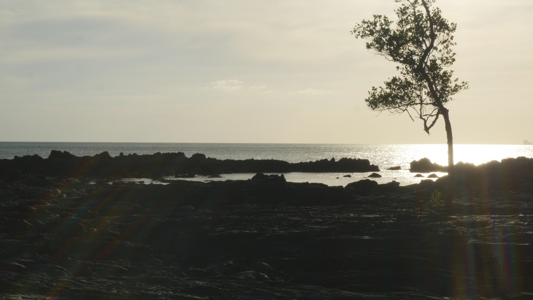
The day was rather hot and exhausting, but satisfying too. After I finished I tweeted that this was the first time in ages that I felt this might be something like a small work. In any case I want to go on working with the tide…

Cami de Cavalls or How to Perform the Earth
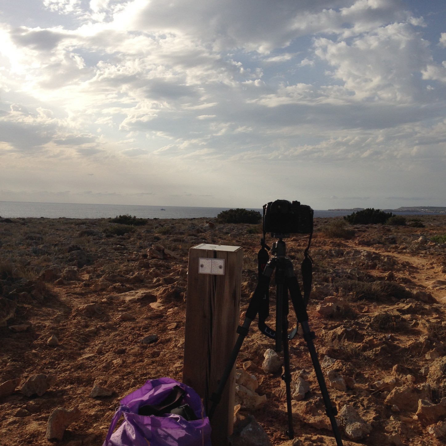
The phrase ‘performing landscape’ feels outdated and quite impossible to use after reading The Ecological Thought by Timothy Morton. Well, the notion of landscape has been controversial for decades, and I have felt the need to explain myself for using it more than once. But now, when my twelve-year project of performing landscape is long since over and done with (although it has not been shown anywhere in its entirety, yet) it is perhaps time to discard the term and find one that feels more suitable for my current concerns. So how about performing the earth? That if anything sounds pretentious, but if we are supposed to think big, as Morton suggests, then why not. And the earth is not only this planet, of course, it is also the soil, the ground, the sand, the stones and the rock I am walking on. But how to perform the earth? Simply by walking on it? For years I used to perform by placing myself in one spot and then returning to that spot again and again to show how everything looked different every time. And of course that technique is still available. Here, on the southwestern shore of Menorca, standing in one spot does not seem the right solution, though. There is a path called Cami de Cavalls circumventing the whole island, and today I walked nearly five kilometers following it, from Cala’n Bosch to Cala Blanca (or whatever the name of the next small cove and tourist resort is). I carried my camera and tripod with me, but did not make a single image. Well, a few snapshots with my phone, just for evidence.
But I thought about alternative ways of performing that path, which follows the coastline and stretches along the rough surface of the cliffs with only a small detour further inland among bushes and low vegetation. One option would be to use the small poles that mark the path as a tool or “rule”, a system to follow, for instance by placing the camera on each pole recording the view along the path from there (and no need to carry the tripod then!). Or perhaps I should stand by each pole and record the image from the previous one, which is not always visible, though. The distances really shift. Or perhaps I should simply record my walk, as I did with my very first attempts in Ireland and in Farrera de Pallars in 1999. What seems clear is the fact that the path is the thing to be performed and recorded. It forms a continuous yellowish line across the land, revealing the soil, the earth, where people and horses have torn away the scarce vegetation. Not many signs of horses on this part of the path, though, neither excrements or signs of hooves. It seems mostly humans have used this path lately and while looking around, it is understandable. The views are great and the path is open, inviting everyone who wants a walk to follow it.

Today, Tuesday, I finally made an attempt. In the afternoon, around five o’clock I decided the sun was low enough to make it worth while to start experimenting. I dressed in a small dark sleeveless dress that I tied up – no scarfs this time – and walked to the start of the path with my camera and my tripod in a simple bag, no backpacks, no fuss. I made the decisions on the spot, like placing the tripod next to the signposts, on the right side facing forward along the path, and at approximately the same height, so slightly lower than normal, and with the horizon dividing the images in half. The gorgeous views of the cliffs and the sea were thus mostly invisible, but the path, the earth itself, the rocks and the soil would be in focus. I decided to walk to the next signpost, stand there for a while – long enough to repeat my ‘mantra’ – and then return to the camera. And then move the camera to the signpost where I had just stood, repeating the action by the next post. This way I walked along the path, returned, walked again with the camera, and so on. I had no idea what it would look like, and whether the next signpost would fit within the frame, since often I could not see the post while placing the camera. When returning home, taking a quick look, the images looked fine. So this is the way to continue tomorrow, or the day after, in the evening light. Perhaps it could become a triptych, walking forwards on the left, standing still in the middle and returning on the right – or then simply a continuation, walking and walking and walking on…

Today, Thursday, I continued my experiment, using the same principles as on Tuesday, starting out around five o’clock. It was easy to find the gate where I finished last time, and now I continued in the wooden part, “metsätaival” as I called it in my mind in Finnish. The brushes obstructed the view of the path, and the sky was covered with clouds, so a few of the images felt really sinister. To make matters worse, there were a lot of bikers and runners on the path, and because of the shrubs I could not see them from a far. So I had to repeat several of the takes since I did not want anybody suddenly jogging in the image. The bushy part of the path ended with a gate, and I thought of finishing there for the day, but the view looked so beautiful and the sun returned, so I went on for a while. While walking I thought about why this rather mechanical way of performing felt so right. With mechanical I mean the system that makes the decisions for me. No need to wonder where to stop walking and stand still for a while, since that is determined by the signpost. And no need to wonder where to place the camera, since that is determined by the signpost, too. And by avoiding all these aesthetic decisions I could focus on enjoying the walk, as well as trusting that the sum total of the decisions made by this “system” would result in a more accurate representation of the path than if I would have tried to find the most pleasing spots to stand and the most interesting views. Of course I could have chosen an even more mechanical system, like using equal distances by counting steps or something, but using the sign posts seems like a more interesting option. Sometimes I could not see the next signpost and would just keep on walking, trusting that it would show up soon. And so it did. And this way I finally solved the problem that has irritated me so often; what I see and what the camera sees are two very different things. Now the camera will see the same view as I do, when I move it to the point where I stood before. Well, since the camera is lower, at the level of my hips, the view is of course not really the same, but closer anyway…
Today, Friday, I continued, and was prepared to finish the project, since they had promised a thunder-storm for tomorrow. Well, I hope that will not happen, since I need to continue for a while. I proceeded rather close to the next village, with the buildings clearly in view in some images, but then the clouds covered the sun and there was less and less light and finally I realized nightfall was quickly approaching. To make matters worse my memory card was full for the “last” image, which was rather dim anyway. Part of the delay was due to people walking their dogs or jogging or whatever, which forced me to wait or to repeat the action. Part was simply my miscalculation. I really had to hurry to get to the village before it was dark, although I felt reassured by the thought that since it was full moon it would not be completely dark. It was very good that I did not try to return the same way, since it was already night when I reached the pavement of human habitation. Then a bus to Ciutadella, and another one from there to Cala’n Bosch. What a trip! But I sure want to make a fourth attempt tomorrow, to finish the path…
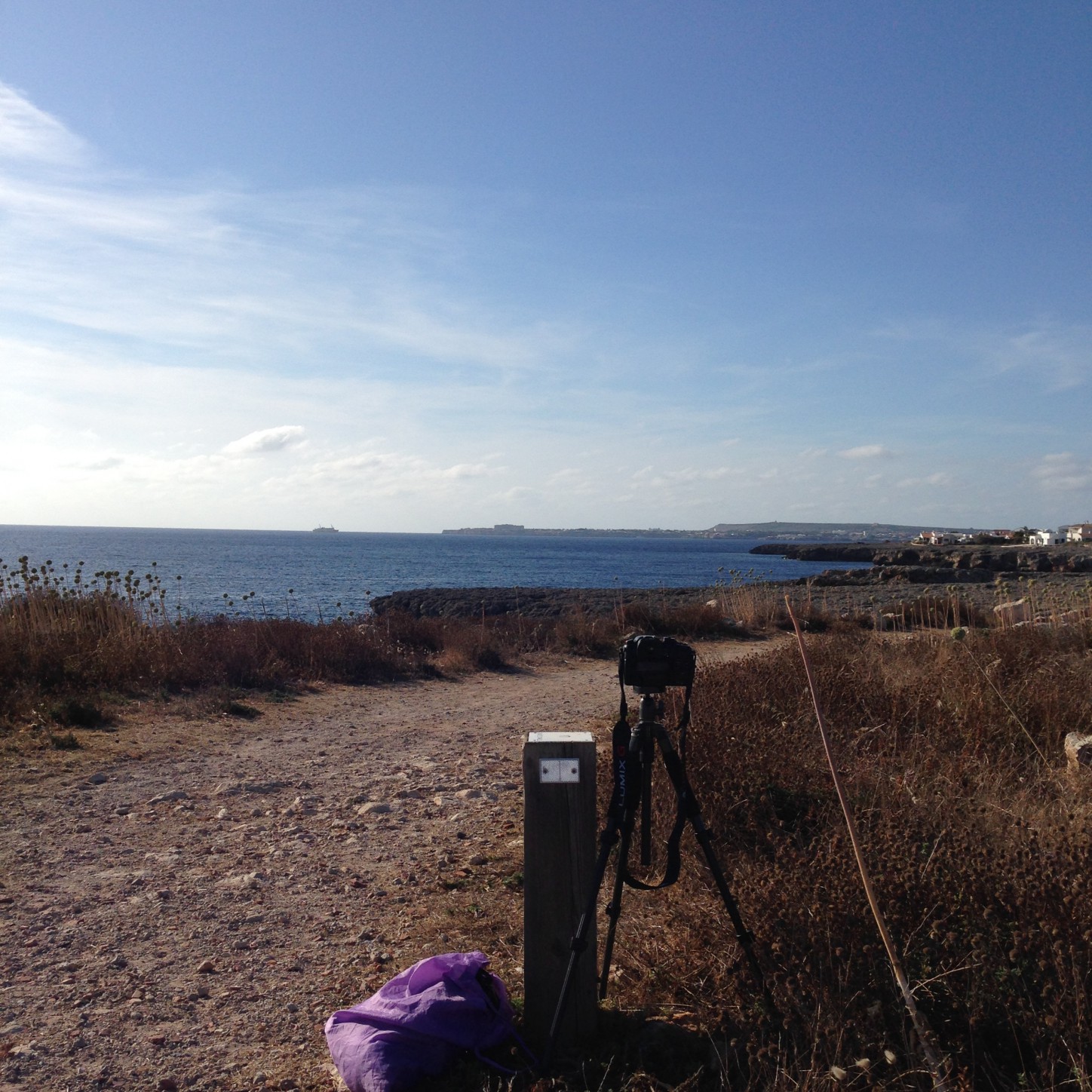
Saturday, last session, and starting with thunder. I left already around three o’clock, since the sky was overcast, so I could as well start earlier, I thought. Near the roundabout on the way a sudden rainfall with thunder suddenly struck, and I spent half an hour with an ice cream in a bar nearby. The sky looked ominous, but when the rain was over I decided to continue, and walked across the cliffs hoping for brighter skies. And yes, by the time I was near the place where I stopped videoing yesterday, the sun was already out. So I started my fourth session in full sunlight, and remade a few of the last images from yesterday. The remaining part of the path was quite long, after all, and some of the images I had to repeat because of frequent passers-by. But it was nevertheless not yet seven o’clock when I was done. And instead of going to have a drink in a bar in Cala Blanca, I decided to walk all the way back, to enjoy the views at a leisurely pace for a last time. Oh dear, it was an exhausting walk. I forgot how long it feels, when one’s feet are sore from stepping on all those sharp stones. The sun was low, so the heat was not bad, but my water was finished and I was, well, exhausted. But I made it, and now I write this at the bar Es Far d’Artrutx. It’s done! Hopefully this will become a finished work, too. And perhaps this way of performing the earth, simply by walking on the earth, will become a new practice to continue…

